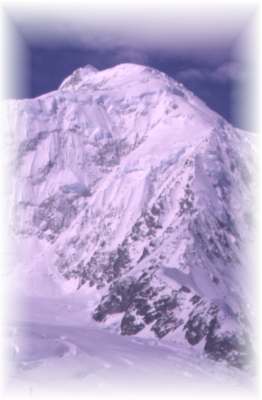
Mt. Logan, East Ridge.
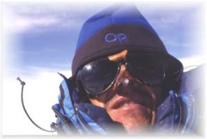
Text and photo by Martin Minařík
Based on volume, Mt. Logan is the largest mountain on the world.; it is the highest mountain in Canada and the second highest mountain in North America. My first information about this mountain came from the book In The Icefield Range of Yukon, by Dusan Macko, a member of the Slovak Expedition which climbed East Ridge of Mt. Logan in 1984. But part of the beauty of climbing in the St. Elias Range is that there is almost no information available. This greatly increases the sense of adventure. I was told by a climber from the area that those who climb in these mountains do not want to bring the crowds in. As a result, those who have the knowledge to write some kind of guide book will not do it. Since my return from the mountain, I can understand why. There are endless glaciers, as well as mountains and routes which have seldom, if ever, been climbed. At a time when crowds are everywhere in the mountains, it is hard to imagine that there are still quality mountains devoid of people.
|
I wanted to traverse Mt. Logan by ascending the East Ridge and down the King Trench. I felt fortunate when three very good friends became excited about this route and our team was formed. The search for information was left to me as the winter months are relatively free for a person who makes a living by guiding hiking and bike groups in Central Europe. I spent hours in the Mountaineers Library in Seattle, WA, reading stories written by expeditions who climbed in the Icefield Range before. However the most important source of information was a person who climbed the East Ridge last year and showed me the slides.
Finally on May 12, 1998 I found myself hitchhiking on the Alaska Highway from Whitehorse to Kluane Lake - alone. My partners had changed their mind and decided to go a few weeks later to attempt the Cassin Ridge of Mt. McKinley. I felt betrayed by my friends, especially since just three months earlier I was forced to climb the Polish Glacier on Aconcagua alone when my partners backed out at the last minute. Since I did not want to give up this climb after spending several months of intensive planning, I decided to climb alone.
The Kluane Rangers were not happy when I told them that instead of four of us there would be only one person. For safety reasons they do not like to see solo climbers. Even I became a bit nervous when the pilot asked for payment in advance; climbers in groups were allowed to pay at the end of their trip. Finally, on May 15, the weather was clear and Andy Williams dropped me off on the Hubbard Glacier, about 5 miles from the East Ridge
All of the other parties I met on Logan climbed with a relatively light pack, and used sleds and skis on the Hubbard Glacier. They would carry loads up high and sleep low, always leaving some food behind in snow caves. And, of course, all of the other parties carried ropes and group climbing gear, such as ice screws, snow pickets, and shovels.
In one sense it was much easier for me. Since I had no partner, I had no rope or group climbing equipment. This gave me a big advantage. Since everything I was taking was in one pack, I did not have to ferry loads and do everything twice.
On the Hubbard Glacier, old tracks from sleds and skis were visible, and my snowshoes helped a great deal. According to the pilot and rangers, there were a few climbing parties on the East Ridge; however I found nobody in the camp underneath the face. Listening to the music of avalanches from nearby Hub Sew Ridge, I felt asleep, spending my first night in the Icefield Range.
Climbing in Alaska and the Yukon offers one great advantage (and many disadvantages): you do not have to get up early. You can comfortably start climbing at a time, that in other regions, such as the Alps, you would have to be off the mountain and down at the huts. I found the snow to be in very good condition, and progress was smooth. It was windy on the ridge, but I found it still relatively warm if I kept moving. It is difficult to describe the weather: partly sunny, partly foggy, mostly windy.
The weather soon worsened, and I met a party of four climbers. They had summited and were running down the mountain as fast as they could. A little higher up I found a camp site with a tent and other climbers. The weather suddenly cleared and the wind was blowing only on the upper parts of the mountain. I was at 11,000 feet, with incredible views of HubSew and McArthur Peaks.
I spent the night there, sharing the camp and cooking in a snow cave with two Canadians and one British climber. The next morning brought perfect weather: bright sun and little wind. The Canadian and British climbers had left already, but I met them again couple thousand feet higher. They offered to let me stay with them that evening, but I felt good and decided to set camp higher up.
The climbing was wonderful! It was mostly hard snow, a few cornices (but only to one side), and some easy water ice. My pack was heavy, but I was gaining altitude fast. I finally placed my tent at about 13 000 feet. I was a bit worried about altitude sickness, since it comes on fast and it can paralyze a person.
But the weather made my worries about altitude sickness irrelevant. Clouds surrounded the valley and a strong south wind started to bring fresh snow from the Gulf of Alaska. Storms here can last a very long time with nine feet of snow accumulating overnight. On the third day of the storm I gave up getting out of the tent to shovel the snow from around the tent. My tent was completely buried by snow, and the comfort level could not be worse. Icicles were hanging from the ceiling of the tent, the space was barely big enough to sit in, everything was wet, and the battery in my altimeter watch went dead. Things were grim.
Finally on the seventh day of the storm the weather cleared a bit and I could climb out of the tent. I saw a group of people coming down; with icicles on their beards they looked even more miserable than me. They had spent the whole storm 3000 feet higher on the plateau, and were forced to dig a snow cave completely exposed to the wind in 40 below weather. But they told me that high pressure was coming and offered me their leftover food and gasoline. I felt very pleased with the news about the coming good weather, but I refused the food and gasoline.
The sun does wonders for one's attitude, and I was in very positive mood. The group left, and I decided to cook well this evening and be ready to move higher up the next day. Unfortunately the next morning looked quite different than I had expected. There were strong winds, and the clouds were moving in and out. This was far from the high pressure I expected. The good times were gone, and I started to dream about the previous offer of extra food and gasoline. In the afternoon I decided to move my camp higher up the mountain. The group had told me about the cave they made 3000feet higher, and I was hoping to get there by the end of the day.
But that was not to be. There was deep snow up to my knees which slowed me down a lot. The slope was steep, not a knife ridge like lower down, but rather unstable snow slopes with some ice seracs. After three hours with zero visibility, I saw a wand and a hole below it. What luck! I had found large snow cave made by some other group of climbers.
I could only dream about a place like this, although it was not all that great. I had to dry my down parka and fleece pants which would certainly be needed higher on the mountain. They got wet during the seven day storm when I kept them under my sleeping bag, and then they froze. I was trying to dry them inside my frozen sleeping bag - on my body. I was shivering most of the night, with little sleep until the early morning.
Suddenly bright light came through the holes in the roof of the cave. Sun ! High pressure had finally arrived.. But for how long? Maybe three days? This would be enough to get me over the summit and to the safety on the lower slopes of the other side. I could then probably survive another shorter storm with my remaining food and gasoline.
The deep snow was taking away some of the excitement from the great weather, but slowly I was moving. Long upper slopes and a traverse to the left took me on to the plateau. There were no more technical difficulties ahead; crevasses and strong wind, together with bad judgment, were the main dangers.
I finally found the cave the climbers had told me about and spent a relatively comfortable night (although they could have made the ceiling higher). I was able to dry some of my clothes on my pack, and even though it was wet my sleeping bag was still warm.
From this point on the mountain, climbers usually go for the summit and return; without their large pack. Although I had to take my pack with me, I had the advantage of having snowshoes to cross the plateau. Because of them I was able to move relatively quickly.
Mt. Logan has several peaks and the summit day has to be accompanied by good weather otherwise it is not possible to climb it. This was the second day of high pressure, but high winds made everything difficult. After reaching the col between the East and Main Peak, I decided not to carry the pack over the highest point. Instead I began traversing from the north, and made plans to cook dinner, climb the mountain fast and light, and then keep descending the plateau until I found a place to camp. But again the weather had other plans for me.
I thought I might be able to find another snow cave, since some spots with pieces of ice looked like they might hold a cave. There was none. I then tried to make my own, but was unable to do so. The worst thing was that I did not know exactly what I wanted to do, and yet I knew that making the right decision was crucial. It was critical for reaching the summit, for not getting frostbite, as well as for staying alive. Descending further from the main summit I found a bunch of rocks that was visible from everywhere. I was finally able to dig a hole under the rocks, which offered some protection from the wind. It was obvious that I would not make the summit that evening, and I was not even sure if I would be able to make it the next day. I could not start my stove, and therefore was unable to melt any snow for water. And without water, I could not eat.
|
I put on all of my clothes and climbed into the frozen sleeping bag. Sleep was impossible. I knew at this point that I would keep going down the other side; it was just matter of whether I would first make it to the summit. The next morning was even worse. I felt like I had a huge hangover, and could not move. I was completely dehydrated, and it was even impossible to put even a few peanuts or chocolate into my mouth. I looked at the summit, which was two miles away and only a couple of hundred feet higher. After a good hour I climbed out of my sleeping bag and put on the plastic shells of my boots (I slept with the inner boots on) and then the overboots. Even with this technology, my feet immediately became cold. Furthermore the wind was even stronger than the previous day. I did not even try to start the stove, for it would be futile. I grabbed the camera, one ice axe, one ski pole, and went for the summit. Exhausted, I could take 40 steps, then I would have to sit down and breathe. I had not eaten or drank for 24 hours. I was slowly moving towards the small col on the summit ridge. But as soon as I reached it, I was nailed down by the wind. There were long periods when I lay on the ice slope - getting ready to fly away. For the first time in the mountains, I was begging the wind to slow down, begging the mountain for mercy. I finally reached the summit on my knees. I stayed there for about 10 minutes. After I taking several pictures, I quickly climbed down the steep west side which was relatively wind free.
I returned to my snow hole where I left the pack, quickly packed up, and started the long traverse of the Logan plateau to safety. About an hour later the wind completely stopped. I immediately started the stove and made a hot drink and meal. These are small but important pleasures in the mountains. It helped, and I received some energy.
The Logan plateau is a huge icefield about 18 000 feet high. The route I took down is the one climbed by the first expedition in 1925. The route starts at the Quintino Sella Glacier and goes under the north face of King Peak. Then from Prospector's Col it goes lower and then higher up the plateau. The first expedition at one point turned around and started to walk back towards the summit. Things did not look quite right and they decided to turn around. This saved their lives.
I did not exactly know what Prospector's Col looked like; furthermore it is difficult to accurately determine distances up there, and my altimeter was dead. Traversing West Peak, I saw King Peak ahead of me. So I climbed up to the ridge and saw an easy glacier heading towards King Peak. An hour later, I realized that this glacier was not going to take me to the King Col, but was taking me directly to the South Face. I had missed the right Col by about 3 miles.
Suddenly I fell into a crevasse. I only fell in up to my butt, but this was a wake-up call. I immediately returned to the plateau and spent the night in my tent. Fortunately I was able to cook and sleep after the terrible night before.
The next morning, I saw a group of ten people skiing down from Prospector's Col, heading over the plateau for the summit. This group had everything that modern climbing and technology has to offer: radios, cellular phones, GPS, skis, and sleds with plenty of food. When I asked them what the time was, they probably thought I was insane.
We parted and I kept walking towards Prospector's Col. On the other side - there was a comfortable glacier heading down by the north face of King Peak, where there were plenty of people, few crevasses, and warmer weather. For the first time after 4 days, I was lower than 18 000 feet. The evening sun was shinning into my eyes as I walked towards the landing strip.
Two days later I was hitchhiking from Kluane Lake back to Whitehorse.